Welcome to our website !

longest rivers in the world


Paraná River, Portuguese Rio Paraná, Spanish Río Paraná , river of South America, the second longest after the Amazon, rising on the plateau of southeast-central Brazil and flowing generally south to the point where, after a course of 3,032 miles (4,880 km), it joins the Uruguay River to form the extensive Río de la Plata estuary of the Atlantic Ocean. See also Plata, Río de la.

Related image


The Paraná River’s drainage basin, with an area of about 1,081,000 square miles (2,800,000 square km), includes the greater part of southeastern Brazil, Paraguay, southeastern Bolivia, and northern Argentina. From its origin at the confluence of the Grande and Paranaíba rivers to its junction with the Paraguay River, the river is known as the Alto (Upper) Paraná. This upper course has three important tributaries, namely the Tietê, the Paranapanema, and the Iguaçu, all three having their sources near the Atlantic coast in southeastern Brazil. The Alto Paraná’s passage through the mountains was formerly marked by the Guaíra Falls; this series of massive waterfalls was completely submerged in the early 1980s by the reservoir of the newly built Itaipú dam complex, which spans the Alto Paraná.

From its confluence with the Iguaçu River to its junction with the Paraguay River, the Alto Paraná continues as the frontier between Paraguay and Argentina. When it is joined by the Paraguay, it becomes the lower Paraná and commences to flow only through Argentine territory. Near Santa Fé, the lower Paraná receives its last considerable tributary, the Salado River. Between Santa Fé and Rosario the delta of the Paraná begins to form, being 11 miles (18 km) wide at its upper end and roughly 40 miles (65 km) wide at its lower end. Within the delta the river divides again and again into distributary branches, the most important being the last two channels formed, the Paraná Guazú and the Paraná de las Palmas.

Related image


The volume of the lower Paraná River is dependent on the amount of water that it receives from the Paraguay River, which provides about 25 percent of the total; the Paraná’s annual average discharge is 610,700 cubic feet per second (17,293 cubic metres per second). The basin of the Alto Paraná has a hot and humid climate year round, with dry winters and rainy summers. The climate of the middle and lower basins ranges from subtropical in the north to temperate humid in the south, with less plentiful rainfall. The Alto Paraná has two zones of vegetation, forests to the east and savanna to the west. Forests continue along the Paraná downstream to Corrientes, where the savanna begins to dominate both banks. The Paraná River has a rich and varied animal life that includes many species of edible fish. Much of the Paraná basin is economically unexploited. The main dam of the huge Itaipú project on the Paraná River was completed in 1982 and had a power generating capacity of 12,600 megawatts. The Yacyretá Dam on the lower Paraná River began operation in 1994. The lower river is a transport route for agricultural products, manufactured goods, and petroleum products, and its waters are used for irrigation of the adjacent farmlands.

Related image


The Mekong River is the 12th longest river in the world. It is about 2,700 miles long.
Its source is the Lasagongma Spring in Mount Guozongmucha in the Tibetan Plateau, and its mouth is the Mekong Delta (South China Sea).


The Mekong River is known by many names. It is called Lancang Jiang (meaning Turbulent River) by the Chinese, Mae Nam Kong (meaning Mother Water) by the Lao and Thai, and Cuu Long (meaning Nine Dragons) by the Vietnamese.

 The Mekong River flows through China, Laos, Cambodia, Thailand, Vietnam and Myanmar.

Mekong River (Source)
 Cambodians heavily rely on the Mekong River for their food supply and livelihood. Almost 80% of the protein intake of Cambodia is dependent on the fish caught from the Mekong River.

 The Vietnamese people rely on the Mekong River for almost half the water used to irrigate their crops.
 The Mekong River serves as a significant transport channel for the Vietnamese people. It is also a trading centre; as the Vietnamese hold their floating markets on the river.
 About 60 million people live in the Mekong River basin.
 Laos is planning on building a hydroelectric dam on the Mekong River. This has been highly controversial due to its possible effect on the river’s ecosystems.
 The Irrawaddy Dolphin, an endangered species, can be found in the Mekong River, and it is also home to the giant river carp (often over a metre long), the Mekong Freshwater Stingray, the smooth-coated otter and the Siamese Crocodile.
Construction of the Myanmar-Laos Friendship Bridge began in 2013 and there are several Thai-Lao Freindship Bridges. These bridges span the Mekong River in places where the river acts as an international border.
In 1540, Antonio de Faria, a Portuguese man, was the first person from Europe to see the Mekong River.
Yanisey river also spelled Yenisei or Enisei, Evenk Ioanesi (“Great River”), river of central Russia, one of the longest rivers in Asia. The world’s sixth largest river in terms of discharge, the Yenisey runs from south to north across the great expanse of central Siberia. It traverses a vast region of strikingly varied landscapes where ancient peoples and customs as well as an enormous economic infrastructure are found.

Related image

The river begins at the city of Kyzyl in the republic of Tyva (Tuva), Russia, at the confluence of its headstreams—the Great (Bolshoy) Yenisey, or By-Khem, which rises on the Eastern Sayan Mountains of Tyva, and the Little (Maly) Yenisey, or Ka-Khem, which rises in the Darhadïn Bowl of Mongolia. From the confluence the Yenisey River runs for 2,167 miles (3,487 km), mainly along the border between eastern and western Siberia, before emptying into the icy Kara Sea. If the Great Yenisey is considered the source, then the river is 2,540 miles (4,090 km) long. The headwaters of the Selenga (Selenge) River, which rise in western Mongolia and flow through Lake Baikal (the world’s deepest freshwater lake) into the Angara tributary of the Yenisey, may, however, be considered the river’s ultimate source. With the inclusion of the Selenga, the Yenisey is 3,442 miles (5,539 km) long and drains a basin that, at 996,000 square miles (2,580,000 square km), is the seventh largest in the world. The system within Siberia’s boundaries comprises some 20,000 tributary or subtributary streams, with an aggregate length of approximately 550,000 miles (885,000 km). All of the major tributaries of the Yenisey flow from the Central Siberian Plateau to its east, a region constituting 80 percent of the basin area.

Image result for yanisey river

Extending for some 2,200 miles (3,500 km) from north to south and for 1,100 miles (1,700 km) from east to west, the Yenisey basin exhibits a considerable diversity of features. Lowlands constitute only 6 to 7 percent of the total area: a narrow strip on the edge of the West Siberian Plain and part of the North Siberian Lowland. In the south the Western and Eastern Sayan, the Tyva, the Baikal, the Hangayn, and the Hentiyn mountains constitute a larger proportion of the basin’s area, with elevations mostly between 2,300 and 7,200 feet (700 and 2,200 metres), steep valleys, and vast bowls between ranges. In southern Tyva and in the Sayans, there are some magnificent higher peaks, culminating in Mount Munku-Sardyk (Mönh SarÄ­dag), which reaches an elevation of 11,453 feet (3,491 metres). Most of the basin stretches over the western sector of the Central Siberian Plateau—with elevations between 1,640 and 2,300 feet (500 and 700 metres). The basin is bordered in the northeast by the Putorana Mountains, which rise to 5,580 feet (1,701 metres); in the west by the Yenisey Ridge, with an elevation of 3,622 feet (1,104 metres); and in the southeast by the Angara Ridge, with an elevation of 3,353 feet (1,022 metres).

The Yenisey River proper is divisible into three principal sections: the 295 miles (475 km) from Kyzyl to Oznachennoye on the southern edge of the Minusinsk Basin, the 544 miles (875 km) from Oznachennoye to the Angara confluence, and the 1,328 miles (2,137 km) from the Angara confluence to the sea.


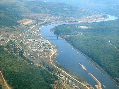
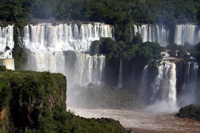
The Yenisey River near its confluence with the Angara River, south-central Siberia.
Masahiro Iijima/Ardea London
Flowing west through the Tyva Basin for the first 115 miles (185 km) from Kyzyl, the Yenisey varies in width from 100 to 700 yards (90 to 640 metres) and often splits into braided channels around gravelly shoals. At the western end of the basin, the river flows into the Sayano-Shushen Reservoir, which receives the Khemchik River. The Yenisey flows north through the reservoir, occupying a now-submerged canyon that cuts across the Western Sayan.

TEST YOUR KNOWLEDGE
The Forbidden City, Beijing. All About Asia
After leaving the reservoir and flowing out of the mountains at Oznachennoye, the Yenisey broadens its valley in the Minusinsk Basin: just below the Abakan confluence, the valley is more than 3 miles (5 km) wide; the bed, about 500 yards (460 metres) from bank to bank, is studded with islands; the flow velocity is reduced to about 6 feet (2 metres) per second; and the long and narrow Krasnoyarsk Reservoir, contained on the east by northwestern spurs of the Eastern Sayan, begins. The reservoir stretches some 240 miles (390 km) downstream to Divnogorsk. Downstream from the reservoir and slightly above Krasnoyarsk, the river valley broadens, as does the bed. Rapids are common there, the best-known being those at Kazachinskiy.

Below the Angara confluence, the right bank of the Yenisey remains an upland and is often precipitous, but the left bank becomes a floodplain. The bed, only 870 yards (800 metres) wide above the confluence, broadens to 3,000 yards (2,700 metres) wide below it; depth increases to between 32 and 56 feet (10 and 17 metres), and the flow velocity drops by 50 percent or more. Farther downstream, however, just above the confluence of the Stony (Podkamennaya) Tunguska River, the Yenisey cuts through spurs of the Yenisey Ridge; rapids occur at Osinovo, and below them the river plunges down a scenic gorge in which its bed narrows to a width of 800 yards (730 metres). Below the confluence with the Lower (Nizhnyaya) Tunguska River, the valley widens to 23 miles (37 km), expanding to about 93 miles (150 km) wide around Dudinka and Ust-Port; the bed’s width increases to 2,700 yards (2,500 metres) and then to 5,500 yards (5,000 metres); depths over the Yenisey’s lower course range from 16 feet (5 metres) to more than 80 feet (24 metres).

The estuary of the Yenisey begins as far upstream as the confluence of the Kureyka (the next considerable tributary north of the Lower Tunguska). Below Dudinka the bed is in places divided by islands, some of them 10 or 12 miles (16 or 19 km) long, and a true delta begins north of Ust-Port, where the numerous Brekhov Islands divide the river into channels, with the westernmost bank about 47 miles (76 km) from the easternmost. The several channels empty into a long, wide bay leading into the Yenisey Gulf of the Kara Sea.

CONNECT WITH BRITANNICA
The largest tributaries of the upper and middle Yenisey are the Khemchik and Abakan rivers from the left and the Tuba River from the right. Fed chiefly by rainwater and melting snow, they begin their spring high water in late April and are swollen by summer rain floods. The Angara, on the other hand, is highly regulated by its source—the huge Lake Baikal—and rarely experiences low water. With a length of 1,105 miles (1,778 km), its own basin of more than 407,700 square miles (1,056,000 square km)—twice the size of the Yenisey’s above their confluence—and a greater volume at its mouth than that of the Yenisey above the confluence, the Angara might better be recognized as the upper course of the main river than as a tributary. The Stony Tunguska and the Lower Tunguska rivers, with an aggregate volume of about 176,000 cubic feet (4,980 cubic metres) per second, also make a substantial contribution to the Yenisey’s runoff.

Hydrology
About half of the Yenisey’s water comes from snow, a little more than one-third from rainwater, and the remainder from groundwater. For the greater part of the system, the eastern Siberian hydrologic regime prevails: violent spring floods are followed first by a rapid fall of levels, then by a slower fall, with summer and autumn rain floods punctuating the sequence; in winter the runoff is reduced sharply, but levels remain high as ice jams are formed. In terms of runoff, the Yenisey is the largest river in Russia, with about 150 cubic miles (620 cubic kilometres) annually. It carries about 10.5 million tons of alluvium into the Kara Sea every year, in addition to nearly 30 million tons of dissolved mineral substances. In midsummer the water temperature varies from 57 °F (14 °C) to 66 °F (19 °C), but freezing begins on the lower Yenisey early in October and affects the entire river by mid-November; ice jams and underwater ice are characteristic. Thawing occurs toward the end of April on the upper reaches, in May on the middle, and from May to mid-June on the lower. The water of the middle Yenisey is highly turbid in spring and summer and contrasts sharply with the limpid water of the Angara; and in summer the two streams flow in the same bed without mingling for 9 miles (14 km) or so from their confluence.

The Yenisey basin has a subarctic climate in its northern part and markedly continental conditions in the middle and southern portions. The cold season prevails from late September to mid-June in the north and from mid-October to late April in the south. Even summer is cool in the northern basin, with average temperatures of 46 to 54 °F (8 to 12 °C) in July, when frosts may still occur; but summer is warm in the south, with July averages between 64 and 68 °F (18 and 20 °C). The average temperature for January in the north ranges from −25 to −18 °F (−32 to −28 °C) and in the south warms to about −4 °F (−20 °C). Annual precipitation averages 16 to 20 inches (400 to 500 mm) in the north; 20 to more than 30 inches (500 to more than 750 mm) in the central portion, and up to 47 inches (1,190 mm) in the mountains south of the basin. The closed depressions in the upper basin receive from less than 8 to about 12 inches (less than 200 to about 300 mm) annually. Most of the rain (80 to 90 percent) falls in the warmer months, chiefly in late summer and early autumn. Snow cover is light in most of the basin, averaging 16 inches (40 cm) in the south, 24 inches (60 cm) in the north, and 35 inches (90 cm) on the Yenisey Ridge. Because the light snow offers little insulation, the soil and subsoil are frozen to a considerable depth for long periods over most of the basin. Permafrost is prevalent north of the Lower Tunguska.

Most of the basin is covered with taiga (marshy, primarily coniferous forest), with Siberian spruce, fir, and cedar predominating in the south and larch farther north. In Mongolia, Transbaikalia, and Tyva there are also steppe grasslands, bordered in the extreme south of the Selenga River basin by semidesert. In the far north of the basin, taiga is superseded by tundra (marshy plain covered with moss and other low, cold-tolerant plants).

The Yenisey and its tributaries are rich in fish: the mountain streams of the headwaters support grayling, trout, lenok, roach, and dace; the middle course has sterlet, trout, goldilocks, several species of whitefish (genus Coregonus), and grayling; the lower course has Siberian lamprey, Siberian sturgeon, sterlet, Alpine char, trout, gold and silver carp, pike, and many others. The estuary has fewer species of fish but is rich in the economically valuable sturgeon. The lower reaches of the Yenisey are also much favoured in summer by migrant waterfowl from the south; the small lakes and islands support ducks, geese, and swans; and the muskrat has adapted to the channels of the delta.

PEOPLE
The peoples of the Yenisey valley are diverse. Around the western headwaters (Great and Little Yenisey), Tyvans (Tuvans) predominate in the rural areas, but they are joined by significant numbers of Russians in Kyzyl, the capital of Tyva. To the north of Tyva the Krasnoyarsk kray (territory) of Russia extends down the entire valley northward to the Kara Sea; its population comprises Russians, Ukrainians, Tatars, and numerous other indigenous peoples. The Khakass people occupy Khakassia southwest of Krasnoyarsk. The vast Evenk autonomous okrug (district), extending from south of the Stony Tunguska to north of the Kureyka, is inhabited both by the Evenk people and by Russians from the west and Sakha (Yakut) from the east. In the far north, the Taymyr autonomous okrug has a majority of Russians and some Evenk but also the Sakha, Dolgan, Nenets, and Nganasan peoples.

ECONOMY
Hunting, fishing, the breeding of reindeer, and fur farming are the traditional occupations of the more northerly peoples, and there is some mining of coal and nonferrous ores (copper, nickel) around Norilsk. Considerable industrial development has occurred in the south, with major centres at Krasnoyarsk, Irkutsk, and Bratsk. The hydroelectric potential of the Yenisey and its major tributary, the Angara—the greatest of any river system in Russia—is also among the most heavily exploited. Since the 1950s, power stations have been built on the Angara at Irkutsk, Bratsk, and Ust-Ilimsk and on the upper and middle Yenisey at Krasnoyarsk and Sayan, with a combined total generating capacity exceeding 25 million kilowatts. Another station on the Angara, at Boguchany, was completed in the late 1980s.

The Yenisey is regularly navigated between Oznachennoye and the sea. A great elevator capable of lifting ships along an inclined railroad between the upper and lower waters of the Krasnoyarsk Hydroelectric Station has been constructed to permit through traffic. The chief ports are Krasnoyarsk, Strelka (at the Angara confluence), Yeniseysk, Igarka, Dudinka, and Ust-Port; seagoing vessels sail up to Igarka. Lumber is the main cargo. Some of the cargo goes upstream to Krasnoyarsk, but the downstream traffic carries bread, coal, petroleum products, and machinery, as well as lumber.

STUDY AND EXPLORATION
Russians first settled on the Yenisey in 1607, when a winter station was established on the Turukhan River (a left-bank tributary joining the Yenisey just below the Lower Tunguska confluence). Novgorod merchants, however, may have been trading with peoples of the valley as early as the 11th century. In 1619 a fort was built at Yeniseysk. Nine years later Krasny Yar (now Krasnoyarsk) was founded, and Irkutsk was settled in 1652. From these places roads went eastward into the Buryat country and southward into the fertile Minusinsk Basin. The Russian hold on the line of the Yenisey was definitively secured early in the 18th century. Exploration of the rivers was then initiated, with a detachment of the Great Northern Expedition (1733–42) operating on the Yenisey. Later, the lower Yenisey was explored by an expedition of 1894–96; and from 1907 to 1912 a party made a more thorough investigation of the entire river. Studies for development plans or for scientific purposes continued throughout the 20th century.
Image result for madeira river facts

Madeira River, an Amazonian tributary that competes with the Amazon for the volume of water that flows through it. Four major rivers merge to form the Madeira before it begins its 2,000-mile journey to join the Amazon 90 miles east of Manaus: the Madre de Dios, the Beni, the Mamoré, and the Guaporé, which forms the border between Rondônia and Bolivia. Jesuits and slave raiders began pushing up the river in 1639. Along their way, the Jesuits converted and captured Indians until after 1719, when the Portuguese settlers eliminated the Torá Indians, who lived near the Madeira's mouth. The Mura, who were brilliant at guerrilla warfare, reclaimed the Torá's territory and prevented settlement along the upper Madeira for most of the eighteenth century.

Image result for madeira river facts

During the rubber boom of the late nineteenth century, the Madeira and its tributaries were used to transport rubber to waiting markets. Steamships began operating on the river in 1873 and could navigate for 800 miles before encountering the Alto Madeira Falls. After that point, rapids and turbulent waters extend for 260 miles and make passage impossible. When the rubber boom ended, Brazilians fished the Madeira mainly for local consumption.

No other major product was extracted from the river until the gold rush of the 1980s. Indians found gold in the river's bottom where the Madeira passes through Rondônia. An estimated half million prospectors battle with malarial mosquitos and other prospectors as they work in rapids and waters up to 60 feet deep to bring up gold from the deep. The mercury used to extract gold from the sand has polluted the Madeira and has poisoned the fish.

The Amur River is located on the border of China and Russia and is a major waterway in the northeastern part of Asia. It’s Chinese name is Heilung Jiang which translates to Black Dragon River. The Amur River is formed by the junction of the Shilka River, which rises in the Russian Federation, and the Argun River, which rises in Manchuria. It first flows southeast and then northeast and empties into the Tatar Straits, which separate the island of Sakhalin from the mainland of Siberia. Its chief tributaries are the Sungari River and the Ussuri River, which also forms part of the Manchurian-Siberian border. It is the third longest non dammed river in the world, beside the Amazon and the Lena.

Image result for sungai amur

The Amur and its 200 tributaries drain an area of 1,844,000 sq km (712,000 square miles) — the tenth-largest river basin in the world and one of the largest in the Russian Federation. Its main tributaries include: Shilka, Zeya, Bureya and Amgun on the left and the Huma, Ergune, Songhua, Ussuri on the right.

The Amur is the biggest shipping artery in Far East Russia. It has little spring flooding because of the limited snowfall in its basin; and in summer, the high-water mark is attained as a result of monsoon rains. When it is ice free (from May to November), the entire Amur is open to navigation. Grain, salt, and manufactured goods are the most important cargoes moving downstream; oil, fish, and timber are the chief products moving upstream.

Although the Amur River is very long, there are few urban settlements on it. The most notable cities that lie on the Amur River are the Khabarovsk and Komsomolsk-on-Amur, both in Russia.

Image result for sungai amur

Oriental White Stork:  The Amur river is a large wildlife area for birds, particularly the Oriental White Stork. The stork is white with black wing feathers. They are quite large with a wingspan of 2.22 meters (7 Ft), can be 110 cm (45 inches) long and 130 cm (50 inches) tall, and weight about 2.8–5.9 kg (6.2–13.0 lb). There are many breading grounds along the Amur river as it provides an abundance of food. The stork’s diet is fish, reptiles, rodent, insects, and small birds. The stork was widely seen across many Asian countries but has become extinct in Japan and Korean Peninsula due to habitat loss.

Amur River Monster!?!:  Also known as the Kaluga sturgeon these beasts grow to amazing sizes. Weighing up to 2200 lbs, these predatory sturgeon have long fueled rumors of “monsters” of the Amur River. Kalugas have been known to be aggressive and there have been reported instances of them capsizing fishing boats and drowning fishermen! The “river monster” has been hunted to near extinction for its sturgeon eggs or roe which is used in caviar. Fishing for Kaluga anywhere in the Amur River is considered illegal and is punishable by law.

Image result for yellow river huang he

The Yellow River Hwang Ho WG) is at the heart of China, both historically and geographically. It is the second longest river in China after the Yangzi 3,400 miles [5,472 kms]. Rising in Qinghai close to the source of the Yangzi at 13,000 feet [3,962 meters] it heads over the mountains to Lanzhou, Gansu the ancient gateway city of China. Turning north into the dry Gobi desert it irrigates the ancient city of Yinchuan, Ningxia before taking a large loop around Shaanxi province picking up its load of loess silt on the way. It then turns north-east between Shanxi and Henan to reach the sea in Shandong.

Yellow comes from the color of the river's waters, for the river carries a heavy load of silt (loess called Yellow Earth picked up from an extensive plateau in Shaanxi, Shanxi and Gansu. It is perhaps the muddiest major river in the world, not only due to the silt but because of evaporation and infiltration in its lower half. The river can carry as much as 82 pounds [37 kgs] for every cubic meter of water. This heavy load of silt is both a great bonus and a curse. Like the lower Nile where the regular deposition of rich alluvial silts gave birth to the Egyptian Civilization, the Yellow River valley was the cradle for the creation of Chinese Civilization. The settlers who farmed the rich alluvial covered lands close to the River generated predictable harvests had an edge over the wandering herdsmen and hunters. In the upper stretches, the water from far away glaciers producing a steady, reliable flow throughout the year. The control of the river for irrigation led to many technological innovations. In the Spring and Autumn period separate kingdoms had to co-operate in order to manage the waters, which was another spur to cultural development. It has been said that the co-ordinated mass effort needed to try to tame the Yellow River is the very reason that a strong, authoritarian government was needed in China.

Related image


Yellow river, waterfall, river

Hukou Waterfall on the Yellow River

Image result for yellow river huang he waterfall

It was only after the Han dynasty that it was called the ‘Yellow River’ previously just ‘The River’ would do. May be, in these days the land was rich in forests and it is the man made clearance of forest and farming methods that has greatly increased the loess load that the river transports and so its color has changed to yellow. The Chinese character for yellow is huáng originating from a picture of a precious object - a Jade pendant. Yellow or perhaps a better translation 'golden' has been the color of Emperor's robes since the Tang dynasty and the name of the legendary Yellow Emperor  founder of China. The river and its color has been very important to the development of Chinese culture.
Related image

The river Brahmaputra is the symbol of power and majesty for the people of Indian subcontinent...This extremely powerful river has not only caught the imaginations of farmers of the river valley but also the adventure sports.

Tsangpo - Brahmaputra in Tibbet


The river brahmaputra is one of the major river in the world. It originates from Mansarovar near Mount Kailash in the Himalayas, flows via Tibbet, China, India and Bangladesh to Bay of bangal. The total length it travels from Himalayans to the Bay is 2900 Km. 

In Tibbet the river is known as 'Tsangpo'. It follows the great Himalayans in its course till India with an avergae height of 4000 meters. It enters India in Arunachal Pradesh where it is called 'Siang'. It then flows down to the plains of Assam, where it is called Dibang. It joins with other two giant rivers, Dibang and Lohit. There are many tributaries which joins Brahmaputra on both northern and southern bank of the river in Assam. With all it's tributaries, the river creates the fertile Brahmaputra Valley of Assam. After Assam Brahmaputra enters Bangladesh where it flows for 240 kms to meet Ganges. It is called Jamuna there and finally flows into the Bay of Bangal. The Brhmaptura river is the lifeline of the all the people living in Assam and Bangladesh. 
Some interesting facts about Brahmaputra:

1. In the Tibbet and Himalayan region, Brahmaputra flows at an average height of 400 eters for 13000 kms. This highest for any major river in the world. 

2. The mighty Brahmaputra is supposed to be on of the most powerful river in the world. Based upon the flow rate, Brahmaputra is the fifth strongest river in the world. 

3. The Brahmaputra is one of those vwey few major rivers in the world which exhibit 'tidal bore'. It means incoming tides form waves that travel up the river against the direction of the current. This is what called a true 'tidal wave' in geography. This is one of the reason behind Brahmaputra's enormous strength. 

4. 'Majuli', the largest island created by a river also resides in the Brahmaputra. This river island is situated in Assam and around 100 km in length. 

5. The Brahmaputra along with Ganges create the largest delta in the world, Sundarban in Bangladesh. 

6. The average width of Brahmaputra is close to 10 km in plains which is on the widest in the world. 

7. Where Brahmaputra enters India is till date on the most remote and adventurous part of the world. The river flows rapidly down to the plains from a height of 4000 meters in this region. This unknown region had trapped imagination of British for many decades in 19th century until it was discovered. 

8. The rivers are considered to be female in India. But the Brahmaputra is the only male river in India. 

Brahmaputra in Indian Mythology:

Brahmaputra means the son of the Hindu Lord 'Brahma'. 
There are many mythological stories on Brahmaputra. But the most popular and sacred one is about the river's birth in 'Kalika Purana'. It describes how Parashurama, one of the ten incarnations of Lord Vishnu, got rid of his sin of murdering his own mother with an axe (or Parashu) by taking bath in this sacred river. On strict order from his father Yamadagni (who had suspected his wife Renuka of adultery), Parashuram had to murder his own mother by severing her head with an axe. As a result of this nefarious act, the axe got stuck to his hand and he was unable to take it off his hand. On advice from sages, he started on a pilgrimage and ultimately reached the place, which is presently known as Parashuram Kunda (about 25 km north of Tezu in Lohit district in Arunachal Pradesh). The story says that the mighty river was then confined to a Kund (or Kunda) or a small lake surrounded by hills. Parashuram cut down the hills on one side to release the sacred water for the benefit of the common people. By this act, Parashuram’s axe came out of his hand to his great relief and he knew that he had been exonerated from his sin. 

The Brahmaputra is also called as 'Luhit' or 'Burha Luit' in Assam. It is derived from the word 'Lohit' means 'blood' in Assamese. This name is believed to be related to the story of Parashuram described above. The river Brahmaputra and it's fertile valley is the lifeline of Assam. It's is the symbol of power and greatness for the people of Assam. Majuli, the river island of Assam is the art, culture and religious capital of Assam till date. But equally Brahmaputra has been destructing Assam every year with it's devastating flood after 1950s. The flood issue is becoming the most concerned threat to the economy of the state. The flood also affest wlidlife of Assam like Kaziranga National Park which is the habitat of the endangered One Horned Rhino.

The Brahmaputra is the least polluted of all other major rivers of India. Most of the poluutions are created by Oil Industries of Assam and wastes of cities like Guwahati. The pollution concern around Guwahati is increasing day by day, and it's high time to stop it now or we will have to pay the consequences soon!